Minggu, 30 September 2012

Lake McDonald


Lake McDonald lies on the west side of the continental divide, the counterpart of Saint Mary Lake on the east side.  Based on a quick review of Google Earth, it looks to me like the best developed beaches on the lake may be at the head end, where westerly waves rework sediment delivered by McDonald Creek.

AERIAL VIEW

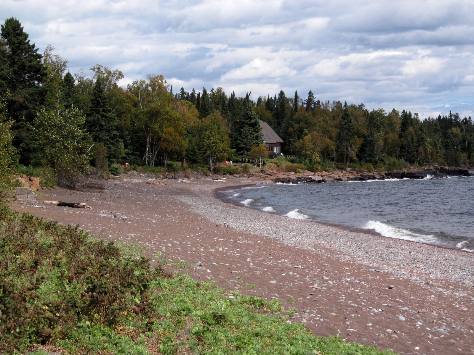
Along the southeast side of the lake, however, small beaches occur in association with minor bumps on the shoreline.  Some may correspond to small stream deltas, but not all do.  This is based on very limited observations, but the shoreline between these points appears to be sediment poor.  These photos are from  one of these small points, where the beach has formed a small cusp at one of these subtle promontories.

Based on some Puget Sound examples, I suspect this may reflect a tendency of promontories on shorelines with highly oblique wave action to act as attractors for sediment (this is related to work done in the last decade by Ashton, Murray, and others, too). This contrasts with the classic coastal model which suggests that headlands should erode and sediment should accumulate in the areas in between. Those examples make sense on ocean coasts with big waves where incidence is more normal to the shore.

In Glacier, most of the beaches consist of green and red pebbles eroded from the Precambrian sedimentary rocks of the Belt Formation.

Saint Mary Lake


Saint Mary Lake, on the east side of Glacier National Park, has some neat beaches.  Unfortunately, I didn't actually get very close to them on this trip, but that isn't stopping me from writing this post.

When I was a kid, our family had to beach our rental canoe when the winds coming down the lake prevented our rounding the point to get back to the boat launch at Rising Sun.  That beach, a narrow gravel berm littered with drift wood, was just below the classic Goose Island turnoff on the Going to the Sun Road (the barrier beach is barely visible in the middle photo).

Two opposing promontories form the Narrows of Saint Mary Lake. The westerly winds that have blown down the lake for thousands of years have built swash aligned beaches on the western shores of each of these points (AERIAL VIEW).  The one on the north shore is the one where I was shipwrecked as a child.  The larger and more interesting beach is a beautiful barrier on the southern shore (see top photo).  The best way to explore it, short of a long hike, would be by canoe or kayak and with a a big can of bear spray.


If you explore the lake with the aerial imagery, you'll find other interesting beaches, too.  There are some neat beaches spreading downdrift from a stream delta on the southern shore (AERIAL).  And more along the toe of the alluvial fan that forms the southeastern end of the lake (AERIAL).

The Importance of College Visits!


Football season is well on its way, the weather is getting cooler, and the leaves are beginning to change. This means two things…the November 1st early action deadline is right around the corner, and there is still tons of time to visit college campuses! Unless you are accepted into an early decision plan for your college, you most likely will have 7 months to decide where you want to go to school. You should be visiting colleges now and once you receive your acceptance letters, if you still haven’t decided, make sure you get back to the campuses and do your due diligence in deciding which environment is the best for you. Remember you will be living at your college for at least 4 years, so you want to make sure it is the best all-around fit for you!

Visiting colleges and universities is one of the most important parts of the college search process. Obviously academics, majors selection, internship opportunities, and reputation are important factors to selecting the right school, but the overall “feel” one gets at a college should be near the top of the list of deciding factors. With advances in technology, most colleges have elaborate websites where there are hundreds of pictures of the school and even virtual tours one can take. Although this is better than nothing, it does not have the same effect as actually walking the campus, watching students interact, sitting in on a class, talking with school faculty, and just listening to your gut reaction to the overall collegiate environment. Every school will be a little different, and the absolute best way to truly know if you will be happy at a certain college is by physically being there and soaking everything in. Also, although it is not always possible, try and visit the school while the college is in session full-time. For most colleges this will be from late August to early May. While visiting a college, you can only gain a true gut feeling and perspective of the school life when students are there and the campus is vibrant with the personality of its students.

The following list contains a few helpful hints and strategies when planning on visiting different colleges on your list:

--As mentioned earlier, try to visit college when school is in session, as that is when you will get the true feeling of the environment.
--Call the undergraduate admissions office at the college you will be visiting to set up a guided tour. This way you will have someone with extended knowledge of the college explain the school’s layout and will be able to answer any questions you may have about the school.
--Think of questions to ask while visiting the college! You will most likely be living at the college you choose for 4-5 years, so it makes sense to do your research on everything about the school and its surroundings. Questions ranging from activities available for students, housing availability, food services, the amount of students that stick around on the weekend, internship opportunities, service opportunities, intramurals, community surroundings, and much more should all be on your list to ask admission representatives at each school.
--If you are traveling far to visit a college, plan ahead and see if there are any other schools that you may be interested in and can stop at on the way. You won’t have that many opportunities to visit colleges, so make the most out of each trip!
--Try to schedule a time to sit in on a college class, and if you know what you want to major in, try to sit in on a class in that field.
--Again, if you know your major, try to schedule a meeting with a professor in that field. This will give you a better idea of what to expect in that major and overall field.
--Take pictures and notes! Hopefully, you will be visiting multiple college campuses. In order to avoid getting schools mixed up, snap some photos and jot down a few notes to keep everything fresh in your mind!
--Soak it all in and have fun! There is no getting around the fact that the college search process in an important part of your life, but most of you will only be doing this once in your life (unless you go to graduate school), so try to live in the moment and enjoy visiting some very beautiful and exciting college campuses, which very well could be your next home!

-Joseph D. Korfmacher, MASC

Sabtu, 29 September 2012

Duluth


Duluth is built at the northern end of an impressive barrier beach tucked into the western tip of Lake Superior.  Much of the shoreline in the Canal Park area has been hardened through more than a century of industrial and port development, but a nice red gravel beach remains in the corner formed between the northern shoreline of the lake (below downtown) and the base of the barrier.
AERIAL VIEW

The urban/industrial context was different, but the red gravel and the multiple storm berms were the same we had been seeing all the way down the North Shore.

I also posted briefly from Duluth during a brief drive-through two years ago (Duluth: June 2010).

Split Rock


Pebble Beach lies in a cove just west of the Split Rock Lighthouse.  The pebble part of the beach is limited to the western end of the little bay and the pebbles run out in both directions.  On the south side, the tombolo looks like it has barely enough gravel to reach its island (see aerial below).  And on the north side, captured in one of these photos, the pebbles transition abruptly to a sediment-starved beach.  The local bedrock is sufficiently resistant so that it may provide little new material to the beach and the beach is left with whatever the glaciers and any local streams originally left it.

AERIAL VIEW


Merlin

The Merlin is not quite a coastal waterbird, but it utilizes much of the same habitat as all of our target species do. As Patrick Comins correctly mentioned while I was discussing them with him, they also use some of our target species for prey. The Merlin, like all falcons, is a bird of open spaces. This may include the coastline and beaches, grasslands, orchards, and farmland. Even while inland they often end up near water, and a forest opening is probably as close as you will find them to closed space. In Connecticut, this means that primarily they can be found on the coast of Long Island Sound. However, some end up in the prime pockets of inland habitat such as this captured individual at the Aspetuck Land Trust's Trout Brook Valley Preserve in Easton/Weston.

Another great location for them is Rocky Hill Meadows, and Timothy Thompson took this series of stunning shots for us.


Thank you Timothy! As mentioned earlier pertaining to our project, the Merlin is a very opportunistic hunter, but it focuses primarily on taking small and sometimes moderately sized birds. Terns and long-legged waders would be out of the question, but shorebirds of the appropriate size and the Horned Lark are targeted on a regular basis. Unlike Peregrine Falcons, Merlins do not stoop on birds from a distance or great height in most cases, preferring surprise attacks or quick runs from a perched position. Timothy's photo in the tree above is most likely where you'll find one prior to an attack.

Merlins are usually only migrant birds in Connecticut, but they can depart quite late in the season and arrive very early in the winter. Occasionally one may try to stick around if we have favorable weather. They are breeding further south each season now with Massachusetts having confirmed nesting birds, and our state is probably due for some soon. If you are out this fall season watching for shorebirds - perhaps conducting an International Shorebird Survey - watch to see these falcons in action as well.


Audubon Alliance for Coastal Waterbirds, Audubon Connecticut and the Connecticut Audubon Society partnering to improve conditions for coastal waterbirds in Connecticut.

Jumat, 28 September 2012

Sugarloaf Cove


This was a neat find, discovered while flipping through a book in the gift store earlier in the morning at Grand Portage.  I was afraid we'd have trouble locating the turnoff, but it turned out to be well marked.  The walk to the beach is a short one.

This used to be a log landing, where timber was collected before being rafted to pulp mills, but it has now been wonderfully stewarded back into health.
UMD - Restoration
North Shore Stewardship Association


I'm sure the industrial history impacted the site topographically geologically and biologically, but I felt I could still sort out some of the beach's story from our short visit.

A rocky point, once an island, anchors the tombolo.  The point reportedly consists of thin-bedded lavas (very old ones), covered with lichen, and visitors were encouraged to avoid damaging the latter. 

AERIAL VIEW

The beach in the cove - an east-facing pocket again - is a mix of boulders, cobbles, and gravel, with the beach coarsening out towards the point.  Some of this may be the inherent sorting one often finds on pocket beaches, but the cobble at the outer end was awfully large for the protected bay.  I suspect that it may be overwash from the coarser grained beach on the exposed side of the tombolo.


Cascade River


This place felt a lot like Acadia National Park in Maine, with its bedrock cliffs, cascading stream, and isolated gravel beach.  I think the road right along the edge and the stone guard rails helped, too.

The beach again faces a little east, rather than directly offshore, suggesting the influence of northeasterly storms in shaping it.  Maybe it was the light, or my imagination, but the beach looked like maybe the red gravel of the last few places is now mixed with gray, possibly signaling some sort of local geologic change.  Could the river be draining an area with darker rocks?

AERIAL VIEW

Grand Marais


Grand Marais is built at the base of a tombolo, so it's got beaches on both sides.  The one on the east side is another broad sweep of reddish gravel, much like some of the beaches we visited earlier.  There's some large riprap and an assortment of partially failed seawalls trying to protect the places where development pushed a little too far across the beach. (Isn't this so often the case, where erosion is essentially a hazard of our own making).

AERIAL VIEW
The beach on the west side consists mainly of a small pocket beach with a sheet pile wall on the tombolo end and an impressive riprap revetment protecting the road and the Java Moose coffee house at the landward end.

The french fur traders left more than one Grand Marais on Lake Superior - we visited another a couple years ago (Grand Marais, Michigan) after visiting the Grand Sable Dunes. A mere 200 miles east of here across the big lake Gitche Gumee.

Kodonce River


Nothing spectacular, just a small stream mouth on a gravel beach.  I guess stream flows must be high enough to occasionally flush out the mouth, but then the waves rebuild the beach right back across.

I don't think that secular changes in lake level can explain the higher berms, so I assume they represent the high water that accompanies big storms on the lake.

AERIAL VIEW

Naniboujou


The highlight of this beach is not actually the beach, but the lodge (hshipman: Naniboujou Lodge), and lunch in the colorful dining room took precedence over exploring the beach.

It's another long, curved gravel beach on the northeast side of a small promontory.  The mouth of the Brule River nudges the beach into the lake just to the southwest.  There have been some feeble, and not terribly necessary, efforts at erosion control in front of the lodge, where waves have nibbled away at the low bank - perhaps the edge of an old river terrace formed at a higher lake level?

AERIAL VIEW

Deronda Bay


This will be the first of several entries from Minnesota's north shore of Lake Superior.  All are based on fairly short visits during a one day drive between Thunder Bay and Duluth.  On a long trip dominated by prairies and mountains, this was the day reserved for beaches.  As usual, the posts are based on a combination of cursory observations and small amounts of pre- and post- trip web-work.  I hope my interpretations aren't too far off the mark - but if you're writing a term paper on the North Shore Volcanic Group or on Lake Superior sediment transport, I recommend you consult more rigorous sources!  But feel free to borrow my pictures.

The bedrock along this shoreline consists largely of mafic volcanics over a billion years old, although they are contained in a broader landscape of gabbro and diabase.  Glaciers modified the surface much more recently, creating the coarse grained sediment that has subsequently been reorganized to form beaches.  The gravel beaches vary from dark gray to red (although red certainly dominates), depending I assume, on local variation in the oxidation of the Proterozoic source rock.  In a blog about beaches, I rarely get to use words like Proterozoic, but I have written about Proterozoic beaches previously, like the rippled Belt Series rocks in the riprap at Shipwreck Point in June 2007 and the beautiful Tapeats beaches at Blacktail Canyon (Cambrian beaches composed of Proterozoic sediment) in June 2009.

The beach on Deronda Bay is typical of many beaches along the north shore.  It is basically a pocket beach, oriented towards the east and therefore fairly oblique to the coastline.  This presumably is a function of the dominant wave action being out of the east.  On straight segments of this coastline with sufficient sediment, this would tend to transport material southwest, forming accumulations on the eastern sides of rocky promontories.

AERIAL VIEW

The gravel was stacked up into a series of berms, suggesting storms at several lake levels.  And the gravel on this beach was uniformly red.  I would have looked more carefully at the lithology, but my mineralogy is as rusty as the oxidized volcanics.  I only picked up the flatter stones, and that was only to see how many times I could get them to skip.


Kamis, 27 September 2012

Chippewa Park


Much of Thunder Bay's waterfront is industrial or otherwise difficult to access.  Marina Park in the north part of downtown was nice, but all riprap.  Chippewa Park south of town has two beaches. The main swimming beach (I guess some people swim in Lake Superior) is a sandy curve along a small cove sheltered by a rock breakwater.

The pictures here are of Sandy Beach, which is more exposed than Chippewa's swimming beach and lies just to the south.  It's the only sand along this stretch, which made me wonder if it could have been trucked in.  The beach is broken into several small curves by rock groins.

This is a uneven stretch of coastline. The adjacent shores are ragged (see aerial below), suggesting that the geology may be irregular (maybe piles of glacial cobble in otherwise soft material, or resistant ledges in softer bedrock). Or perhaps, the shoreline has simply eroded for decades and those little points are old rock groins, sort of like the ones on this beach, but without the sand in between.  I have no idea and only noticed the pattern once I was back in Seattle.

AERIAL VIEW

This beach must be icebound all winter - so wave action is probably most significant in fall before it freezes over.  I don't have enough experience in these settings to know what peculiar things moving ice does to beach gravel, although I assume under certain conditions it can leave some pretty cool landforms - ice thrusts, rafted pebbles, ice scour.

Thunder Bay at hshipman.  As usual, my other blog parallels this one, but instead of rambling commentary about beaches, you get rambling commentary about other stuff.  Sometimes it includes a little non-beach geology; sometimes it just has pictures of food.

Rabu, 26 September 2012

Jon Frank Film

God Music from 'The Reef' starring Ryan Burch from Jon Frank on Vimeo.

Bathymetry from 'The Reef' from Jon Frank on Vimeo.

A couple more clips from Mr. Frank and 'The Reef'. Seriously magnificent stuff.

Western Willet

Patrick Comins had a Western Willet yesterday afternoon at the Menunketesuck Island flats, highlighting a trip where he also spotted a dozen American Oystercatchers and the first of season Dunlin. Take a look at the very crisp photos he snapped of this individual.


This is a subspecies of the Willet, and there is no better explaination on it than this passage from The Birds of North America Online:

This species is composed of 2 disjunct breeding populations differing in ecology, in morphology, and subtly in vocalizations. Populations breeding in inland, primarily freshwater habitats of western states and provinces belong to the subspecies Catoptrophorus semipalmatus inornatus or Western Willet. Populations breeding in the marshes of the Atlantic coast, from New Brunswick to Tamaulipas, belong to the subspecies C. s. semipalmatus or Eastern Willet. The two breeding environments differ in several characteristics. Eastern Willets often have abundant food resources but limited nesting habitat, while Western Willets often have abundant nesting habitat but unpredictable food resources, depending on wetland availability and drought. Ambient sound also differs between the breeding areas of the 2 subspecies, and this has resulted in a divergence in “song” characteristics. The song (“pill-will-willet”) of the Eastern Willet is emitted at a higher frequency and more rapid repetition rate than that of the Western Willet. Calls of both subspecies sound very similar to human ears, but Eastern Willets do discriminate between male songs of the 2 subspecies, responding preferentially to Eastern song. Western Willets tend to be larger and paler than Eastern Willets, with less ornate barring in their breeding plumage. These are average differences, and the 2 races overlap in these morphological characteristics.

Patrick mentions on our Facebook page that he identified it by the long, two-toned bill and very pale color, as the overall body colorations are much lighter on Western Willets. He also mentioned the larger size which may not be apparent without a size reference but is always easy to see if you have experience looking at all of the Eastern Willets filling habitats like Stratford Great Meadows Marsh and associated areas each year, a great place to visit to examine "our" birds up close during the breeding season.


Audubon Alliance for Coastal Waterbirds, Audubon Connecticut and the Connecticut Audubon Society partnering to improve conditions for coastal waterbirds in Connecticut.