Waddell Bluffs


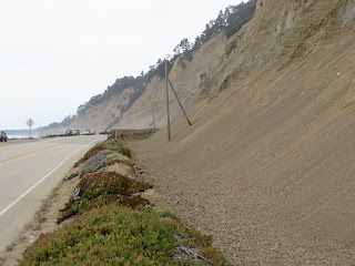
High hills reach the ocean just north of Waddell Creek, on the coastline between Santa Cruz and Ana Nuevo, forcing Highway 1 to follow to the beach.  The roadway is protected from El Nino storms by an impressive riprap revetment and from the still-collapsing bluff by a high fence of cable netting.

Google Maps:  AERIAL VIEW


There's an impressive ledge of exposed rock on the platform that appears to act like a big groin, influencing the shape of the local shoreline.  I suppose it makes it a little easier to protect the road to the north, a little more difficult to protect the road to the south.


Related Posts :

  • Mattole RiverThis was our last look at the coast before seeing it again many hours later down near Point Bragg - … Read More...
  • Point ArenaOur run of great weather has run into summertime coastal fog, which isn't surprising, but certainly … Read More...
  • MacKerricherThe shoreline north of Fort Bragg up towards Ten Mile River includes a series of dune fields blown i… Read More...
  • Ocean BeachAfter so many spectacular beaches in the last few days, I almost hate to include this one, but my be… Read More...
  • Glass BeachLike many coastal communities, Fort Bragg used to toss much of its garbage over the edge.  Folk… Read More...

0 Response to "Waddell Bluffs"

Posting Komentar

wdcfawqafwef